Direct parameter input
This workflow allows execution of operations using saved or predefined parameter sets, enabling automated and reproducible data processing without interactive selection.
Overview
The Run from Parameters workflow enables users to execute operations using configuration files rather than interactive selection. This approach provides automation and reproducibility for various seismic data processing tasks, allowing users to quickly run common workflows without manual configuration.
References and Documentation
The parameters used in this workflow are based on standard FDSN web service specifications:
- Station Parameters (for searching seismic stations)
- Event Parameters (for searching earthquakes)
- Dataselect Parameters (for searching waveform data)
Workflow Steps
Unlike the other workflows that require multiple interactive steps, the Run from Parameters workflow consists of a single step:
Load and Execute Configuration: Load a configuration file containing predefined parameters and execute the corresponding process
This workflow is particularly useful for:
Batch processing of multiple datasets
Reproducible research workflows
Automated data collection routines
Scheduled data retrieval tasks
Sharing processing configurations with colleagues
Step 1: Load and Execute Configuration
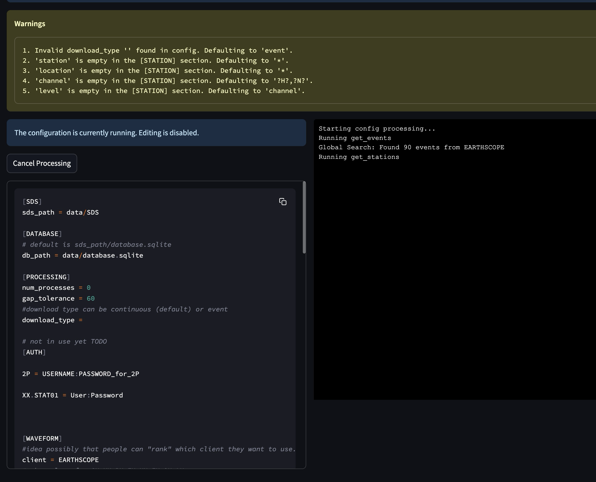
Run from Parameters interface showing configuration and execution log
The Run from Parameters interface allows you to execute seismic data operations using predefined configuration files:
- Configuration Display:
View the currently loaded configuration file
See warnings about missing or default parameters
Configuration sections include: * [SDS] - Path settings for SeisComP Data Structure * [DATABASE] - Database connection settings * [PROCESSING] - Processing parameters like number of processes and gap tolerance * [AUTH] - Authentication credentials for restricted data access * [WAVEFORM] - Client selection and other waveform parameters
- Execution Controls:
The configuration is automatically executed when loaded
“Cancel Processing” button to stop the execution
Real-time log output showing the progress of the operation
- Log Information:
View detailed information about the execution process
See which operations are being performed (e.g., get_events, get_stations)
Monitor the results of each operation
Track overall progress of the workflow
- Technical Details:
The system reads parameters directly from the configuration file
Parameters can specify event criteria, station selection, time windows, etc.
The system automatically determines whether to run event-based or continuous-based processing
Processing follows the same underlying logic as the interactive workflows
Results are stored in the same database and file structure as other workflows
This workflow effectively bypasses the interactive selection steps of the other workflows, allowing for automated execution based on predefined parameters.
Key Features
Parameter-driven execution
Configuration file-based operation
Command-line interface (CLI) support for scripting
Automated processing without user interaction
Detailed logging of processing steps
Support for both event-based and continuous data retrieval
Parameter Reference
| Sec. | Parameter | Description | Examples |
|---|---|---|---|
| DATA | sds_path | Path to the SDS archive where waveform data is stored. Both relative and absolute paths can be defined. Relative path is considered from the location where you run seed-vault. |
Relative paths:
|
| db_path | Path to the SQLite database file. Both relative and absolute paths can be defined. Relative path is considered from the location where you run seed-vault. |
Relative paths:
|
|
| PROCESSING | num_processes | Number of processes used for parallel processing. This parameter is only used when syncing the database[1]. Set to zero to use all available processes. |
0 (all processors)
4 (limit processors)
|
| gap_tolerance |
Maximum allowed gap in seconds before a warning is issued. This is
useful for segmentation of the signals. The
gap controls the time difference between two
consecutive data points to be considered as one signal.
|
10 |
|
| download_type | Defines whether data is downloaded continuously or by event. |
continuous | event
|
|
| AUTH (Optional) | NSLC code |
There is no allocated parameter name for AUTHs. Rather, AUTH lines
should be formatted as below:{nslc code} = {username}:{password}where, nslc code is the {network}.{station}.{location}.{channel} code.
|
AU.MT01 = USER:PASS
|
| WAVEFORM | client | FDSN client used for waveform retrieval. |
EARTHSCOPE
|
| channel_pref | Preferred channels for data retrieval. |
HHZ,EHZ
|
|
| force_redownload | Forces re-downloading of waveforms, evenif they are already available locally and registered in the database. |
True | False
|
|
| days_per_request | Set maximum number of days per data request. | 4 |
|
| STATION | client | FDSN client used for station metadata retrieval. If not defined, it will default to the waveform client. |
EARTHSCOPE
|
| local_inventory | if set, will get the stations defined solely by the contents of this inventory file | {path-to-inventory-file} |
|
| force_stations | force-add these stations to the inventory at the same time (possibly outside of the search) | IU.ADK.00.HH2 |
|
| exclude_stations | Use this parameter if you don't want some stations regardless of anything. | IU.ADK |
|
| highest_samplerate_only | If True, retrieves only the highest sample rate available. |
True | False
|
|
| starttime | Searches for stations that were in operation after this time. | 2024-08-20 |
|
| endtime | Searches for stations that were in operation before this time. | 2024-09-20 |
|
| startbefore | Searches for stations that their commissioning was before this time. | 1990-01-20 |
|
| startafter | Searches for stations that their commissioning was after this time. | 1990-01-20 |
|
| endbefore | Searches for stations that their de-commissioning was before this time. | 1990-01-20 |
|
| endafter | Searches for stations that their de-commissioning was after this time. | 1990-01-20 |
|
| network | Network code(s) to filter stations. If not defined, it defaults to '*' which means all. | AU |
|
| station | Specific station code(s) to retrieve. If not defined, it defaults to '*' which means all. |
MT01,ADK
|
|
| location | Specific location code(s) to retrieve. If not defined, it defaults to '*' which means all. |
00.10
|
|
| channel | Specific channel code(s) to retrieve. If not defined, it defaults to '*' which means all. |
HH2,BH1 | ?HH?
|
|
| geo_constraint |
Type of geographical constraint (bounding box | circle | None). This block
confines the search area for stations. Note: if geo_constraint block is not defined, the app will search stations globally. |
bounding | circle | None
|
|
| minlatitude |
Minimum latitude for bounding box constraint. (only applicable if geo_constraint = bounding)
|
-35.0 |
|
| maxlatitude |
Maximum latitude for bounding box constraint. (only applicable if geo_constraint = bounding)
|
-30.0 |
|
| minlongitude |
Minimum longitude for bounding box constraint. (only applicable if geo_constraint = bounding)
|
130.0 |
|
| maxlongitude |
Maximum longitude for bounding box constraint. (only applicable if geo_constraint = bounding)
|
140.0 | |
| latitude |
Latitdue position of the center of the circle. (only applicable if geo_constraint = circle)
|
-30.0 |
|
| longitude |
Longitude position of the center of the circle. (only applicable if geo_constraint = circle)
|
140.0 |
|
| minsearchradius |
Minimum search radius distance (in degrees). The app searches areas between min and max search radii. (only applicable if geo_constraint = circle)
|
140.0 | |
| maxsearchradius |
Maximum search radius distance (in degrees). The app searches areas between min and max search radii. (only applicable if geo_constraint = circle)
|
140.0 | |
| includerestricted | Specify if results should include information for restricted stations. | True |
|
| level |
This parameter controls the stations are retrieved at what level. If set to station it will only get the stations. If set to channel it would retrieve at channel level. Default value is channel
|
station | channel | |
| EVENT (Optional) | client | FDSN client used for event data retrieval. If not defined it will default to waveform client. | USGS |
| model | Seismic velocity model used. | ak135 |
|
| before_p_sec | Number of seconds of waveform data to include before the estimated P-wave arrival time. Helps capture pre-event activity. | 20 |
|
| after_p_sec | Number of seconds of waveform data to include after the estimated P-wave arrival time. Ensures later seismic phases (e.g., S-waves, surface waves) are captured. | 100 |
|
| starttime | Start time for event query. |
2023-01-01T00:00:00
|
|
| endtime | End time for event query. |
2023-12-31T23:59:59
|
|
| min_depth | Minimum depth of event in kilometers. | 5 |
|
| max_depth | Maximum depth of event in kilometers. | 1000 |
|
| minmagnitude | Minimum event magnitude. | 5.0 |
|
| maxmagnitude | Maximum event magnitude. | 7.5 |
|
| minradius |
This parameter defines the minimum radius (in degrees) to exclude events around each individual station, when downloading waveform timeseries.
Note: Not to be confused with minsearchradius.
|
30 |
|
| maxradius |
This parameter defines the maximum radius (in degrees) to include events around each individual station, when downloading waveform timeseries.
Note: Not to be confused with maxsearchradius.
|
90 |
|
| local_catalog | if set, load events from a local QuakeML file | {path-to-local-event-file} |
|
| geo_constraint |
Type of geographical constraint (bounding box | circle | None). This block
confines the search area for stations. Note: if geo_constraint block is not defined, the app will search stations globally. |
bounding | circle | None
|
|
| minlatitude |
Minimum latitude for bounding box constraint. (only applicable if geo_constraint = bounding)
|
-35.0 |
|
| maxlatitude |
Maximum latitude for bounding box constraint. (only applicable if geo_constraint = bounding)
|
-30.0 |
|
| minlongitude |
Minimum longitude for bounding box constraint. (only applicable if geo_constraint = bounding)
|
130.0 |
|
| maxlongitude |
Maximum longitude for bounding box constraint. (only applicable if geo_constraint = bounding)
|
140.0 | |
| latitude |
Latitdue position of the center of the circle. (only applicable if geo_constraint = circle)
|
-30.0 |
|
| longitude |
Longitude position of the center of the circle. (only applicable if geo_constraint = circle)
|
140.0 |
|
| minsearchradius |
Minimum search radius distance (in degrees). The app searches areas between min and max search radii. (only applicable if geo_constraint = circle)
|
140.0 | |
| maxsearchradius |
Maximum search radius distance (in degrees). The app searches areas between min and max search radii. (only applicable if geo_constraint = circle)
|
140.0 | |
| includeallorigins | Specify if all origins for the event should be included, default is data center dependent but is suggested to be the preferred origin only. | True |
|
| includeallmagnitudes | Specify if all magnitudes for the event should be included, default is data center dependent but is suggested to be the preferred magnitude only | True |
|
| includearrivals | Specify if phase arrivals should be included. | True |
|
| limit | Limit the results to the specified number of events. | 100 |
|
| offset | Return results starting at the event count specified, starting at 1. | 1 |
|
| contributor | Limit to events contributed by a specified contributor. | USGS |
|
| updatedafter |
Limit to events updated after the specified time.
Note: While this option is not required it is highly recommended due to usefulness. |
2023-01-01T00:00:00 |
|
| eventtype | Limit to events with a specified eventType. The parameter value can be a single item, a comma-separated list of items. Allowed values are from QuakeML or unknown if eventType is not given | earthquake |
|
| catalog | Limit to events from a specified catalog. | ISC |
|
| Note: Syncing Database is used when you already have local SDS data available and you wish to add them to the App's database to avoid redownloading them. Note that in the syncing process, the actual data is not added to the database, rather the metadata would be added to hint the App what data is already available locally. | |||